Newmarket's Racecourses
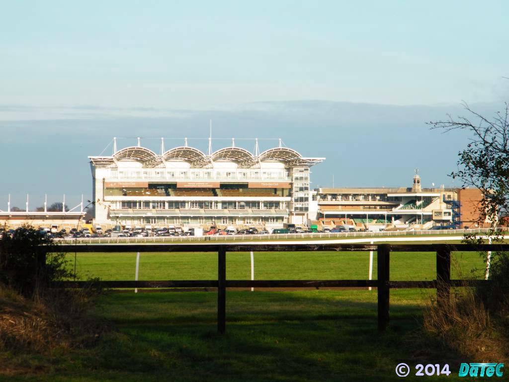 The Millennium Grandstand on the Rowley Mile |
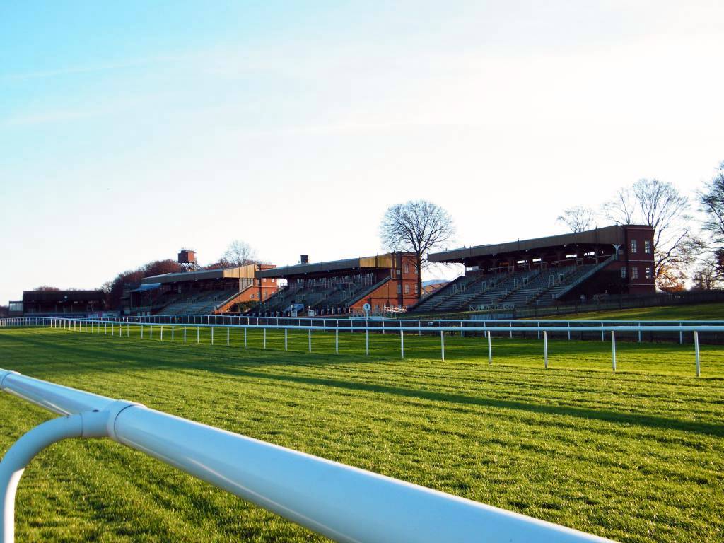 The July Grandstand |
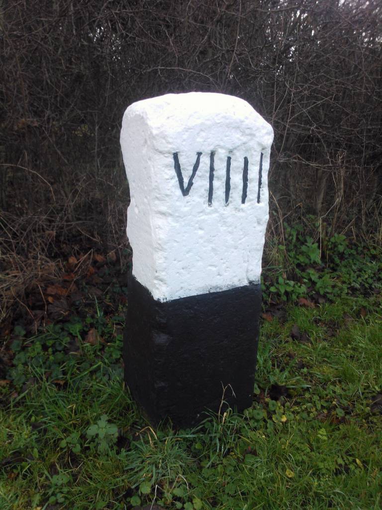
Starting post at the 'Centre of Newmarket' ...
-
It might seem a strange place - the 'Centre of Newmarket' - for the
starting post of the history of Newmarket's racecourses, but the
detailed discussion given below will explain how it's all linked
together.
Originally if you set-off from the milestone (post) that was at side of one of the gates at the into the yard of the Crown Hotel - No.26-28 High Street and continued along the road towards Cambridge you came to the first milestone at the side of the road beside the Cambridge Heath.
If you take that same walk today and carry on further you come to the two-mile milestone marker on the side of the road next to the gated entrance to one of the July Cottages, at the end of the July Course, beside the Devil's Dyke.
Further along the old Cambridge Road you'll come to the third milestone set into the ground at the side of the road.
The fourth milestone is (obviously) in front of Four Mile Stable Farm, painted white these days to make it more obvious .... now consider this - it's thirteen miles from the 'Centre of Newmarket' to the centre of Cambridge - so this milestone also marks that it's nine miles from Cambridge - hence the name of the area is also known as Nine Mile Hill.
Nine Mile Hill Milepost
-
... it's all about 'the distance' - Six Mile Bottom & Four Mile Stable Farm
-
It is also of course six miles from the Crown milestone to Six Mile
Bottom along the London Road .... although an alternative origin for
the name of Six Mile Bottom given by many is that it's six miles
from the start of the racecourse at Newmarket. But Newmarket had
many racecourses and more than one starting post, so it's not
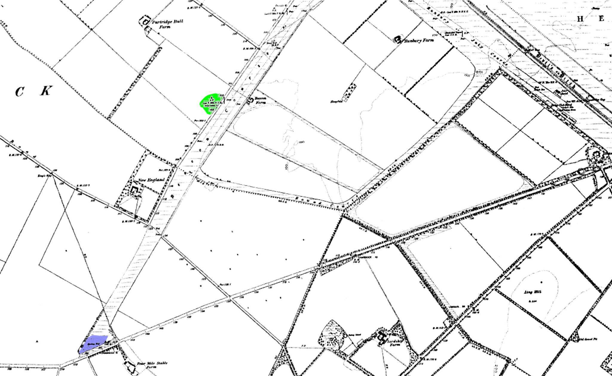
obvious which one was used to denote this distance .... maybe it
was from the one near Beacon Farm (highlighted in green in the map
below), this is approximately six miles from the village going
clockwise around the Beacon and July Course. If we investigate the
history of the racecourses in a bit more detail though all will
become obvious how these names do actually link into Newmarket.
Actually the main starting post for the Beacon Course was another mile further away, in front of the aforementioned Four Mile Stable Farm (highlighted in blue on the map below). As can be seen on this map the Beacon Course went right across the Swaffham Bulbeck Road. This part of the course has been squeezed-out by the A14 / A11 dual carriageway, leaving the starting post for the modern-day longer distance Newmarket races at the location where the Round Course meets the Beacon Course. Although the old course is now gone the original 'Beacon' starting post is kept in the National Horse Racing Museum in Newmarket and in the field where it originally stood there's a replica to mark its position.
-
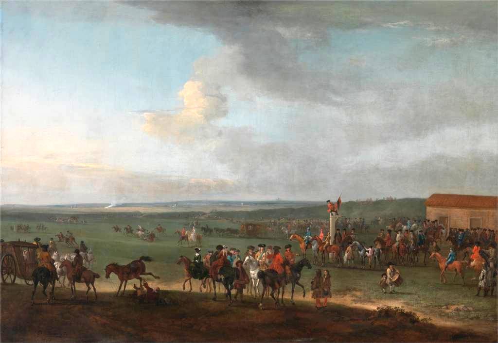
In the round ...
-
Before we discover the origins of the many straight flat courses at
Newmarket, let's remember one that's slightly different and much
less well known. Although it's importance has dwindled over the years, the Round
Course that can be seen in the map below is still used once
year for the Newmarket Town Plate. The race this year was run on
Saturday 24th August 2013. The distance is 3 miles 6 furlongs and
the start is very close to the finish at the weighing post, by the Cambridge
Gap (in the Devil's Dyke), called Thomond’s Post on the July Course, hence the
horses run a clockwise round course. The maximum number of runners
for the race is 30, mostly in the interest of safety.
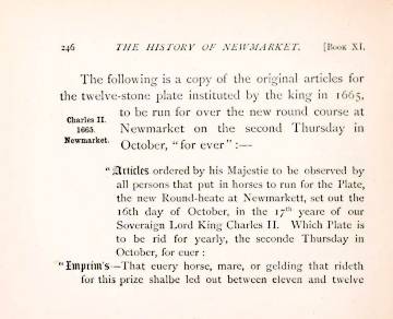
The race was instituted on 'the Monday after the second Thursday in October, 1665' by King Charles II and was first run in 1666 .... he stated that it should be run 'forever'.
Not an expensive race, here's a list of the 2013 entrance fee and prizes:-
- Entrance fee will be £30.
- The prizes will be as follows:
- Owners: 1st - £200.00, 2nd - £100.00, 3rd - £50.00, 4th -
£25.00
- 1st - Goldings
Perpetual Challenge Plate, a silver photograph frame,
a £125.00 Goldings Voucher and a box of Powters Celebrated Newmarket sausages
- 2nd - a £75.00 Goldings
Voucher and a box of Powters
Celebrated Newmarket Sausages
- 3rd - a £50.00 Goldings
Voucher and a box of Powters
Celebrated Newmarket Sausages
- 4th - a £25.00 Goldings
Voucher and a box of Powters
Celebrated Newmarket Sausages
[Click on the picture on the right for the list of rules for the race instigated in 1665.] -
The July Course
-
Without going into much detail on this page the following link is to a very detailed National Horse Racing Museum article about the history of the July Course, with its origins in 1786. There's some wonderful photos on there of the building of the present-day grandstands in 1931:-
-
 http://blog.nhrm.co.uk/index.php/first-runnings-the-july-meetings-feature-races/
-
On the flat - Newmarket's Racecourses in 1890
-
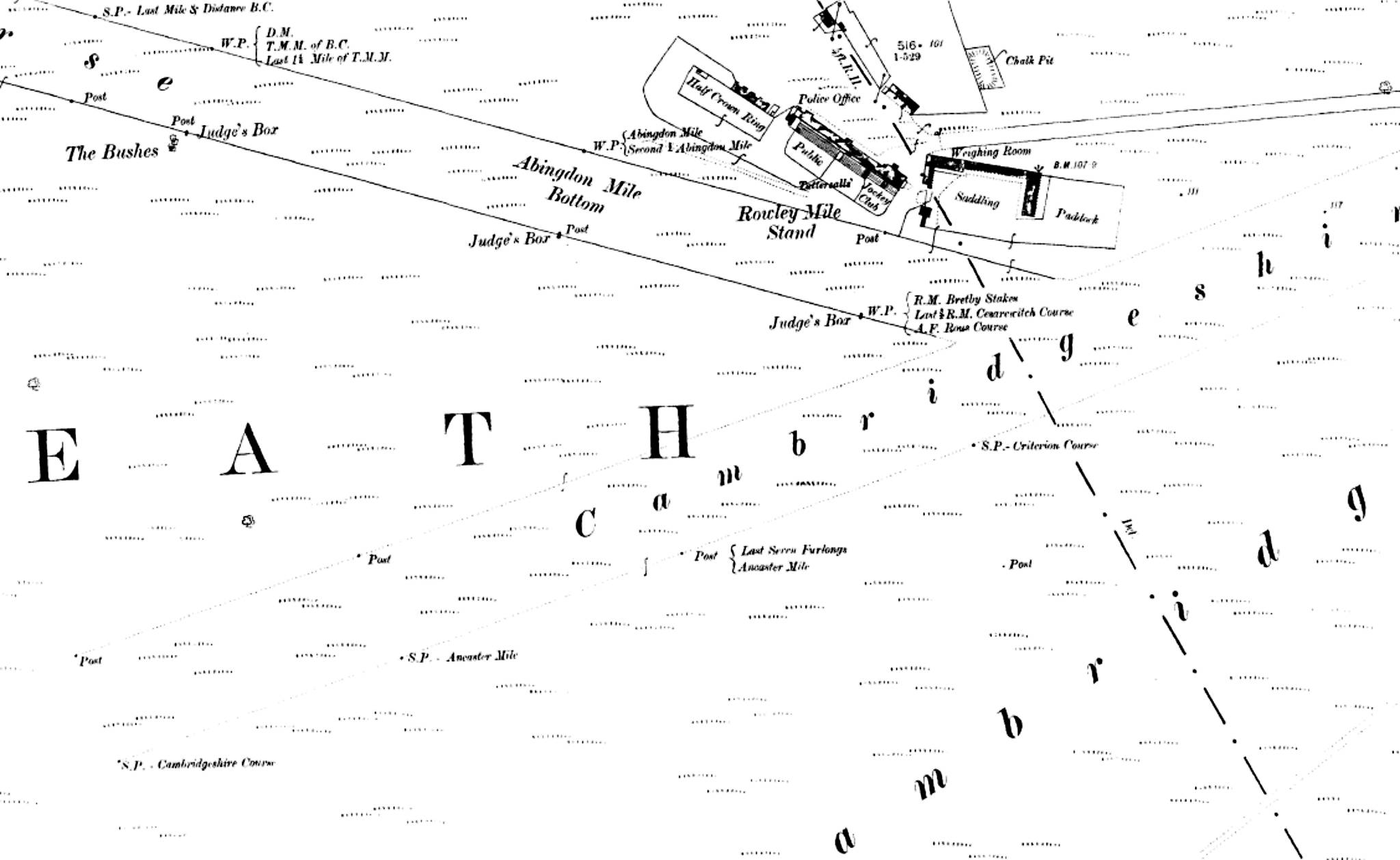
Newmarket's Racecourses - Beacon, Cesarewitch, July / Bunbury and Round Course - 1890
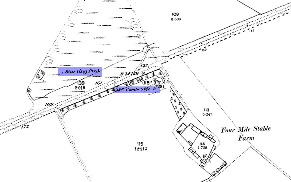
Four Mile Stable Farm - 1890 - Starting Post and Milestone
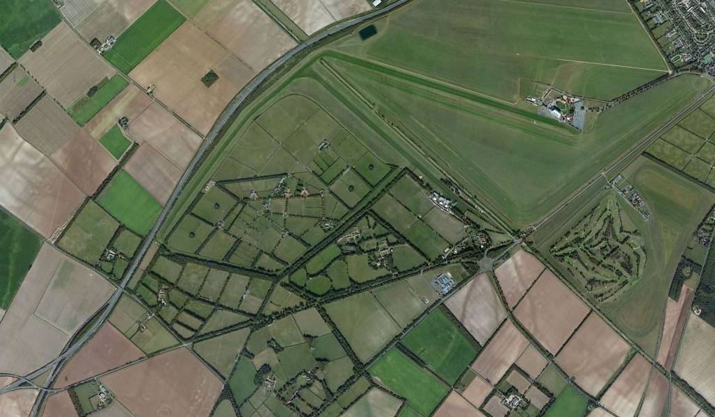
Newmarket's Racecourses - aerial view 2013
-
As noted above, Newmarket originally had many more racecourses, starting
and winning posts
than those that remain today, details of a few are shown on the maps
below, including the location of the Cambridgeshire Stand that
featured in so many paintings of earlier race finishes:-
-
The Winning Posts
-
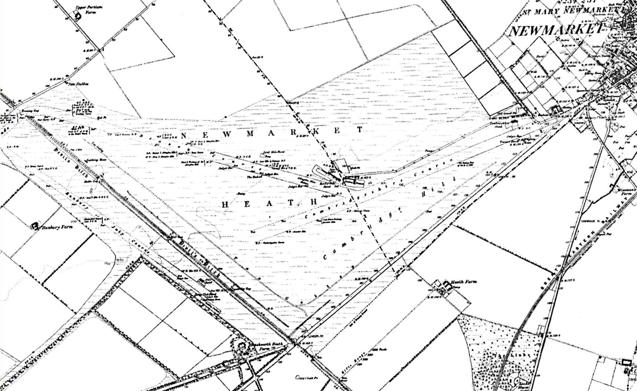
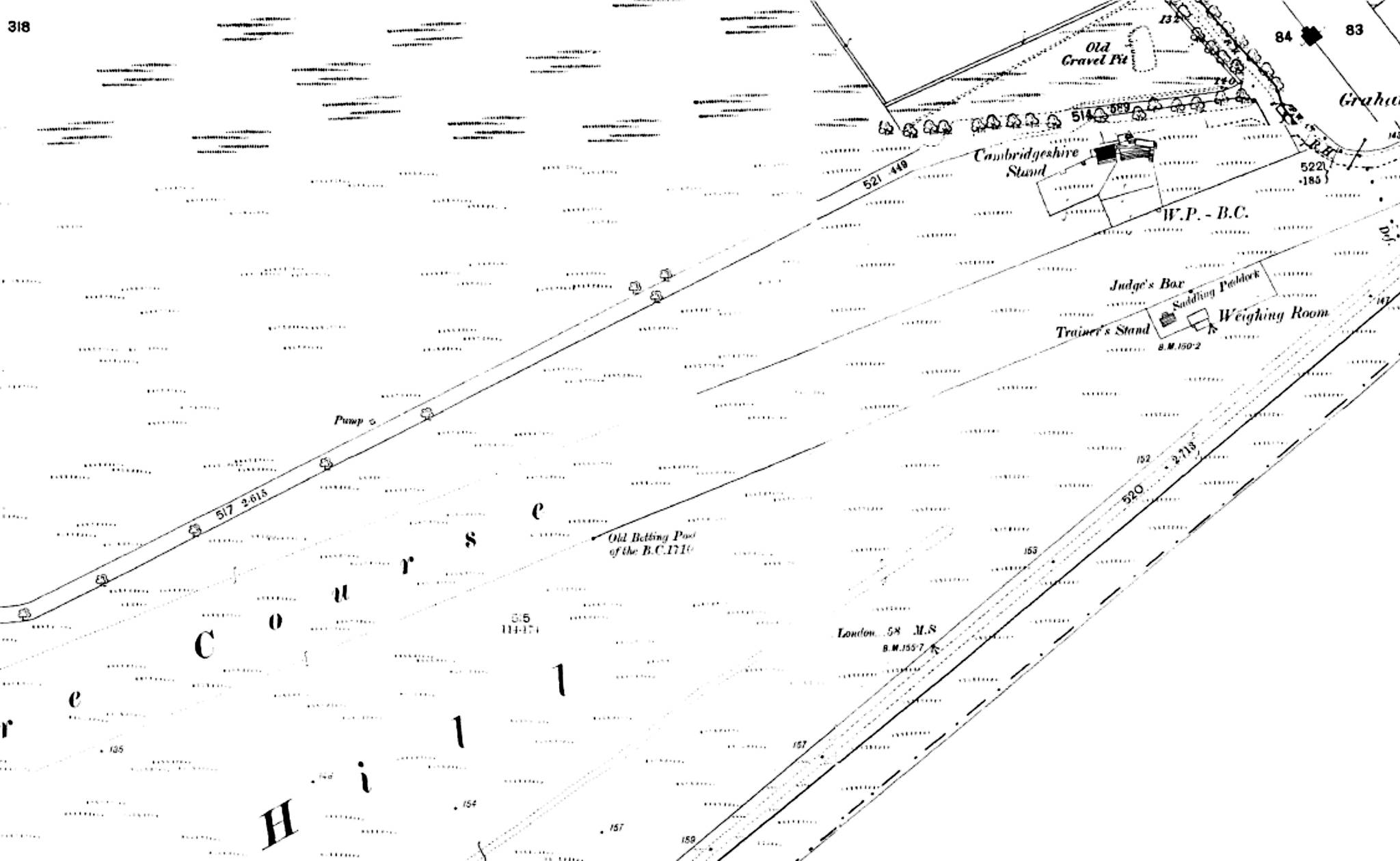
Newmarket's Racecourses - Rowley Mile, Beacon, Cambridgeshire and July / Bunbury Course - 1890
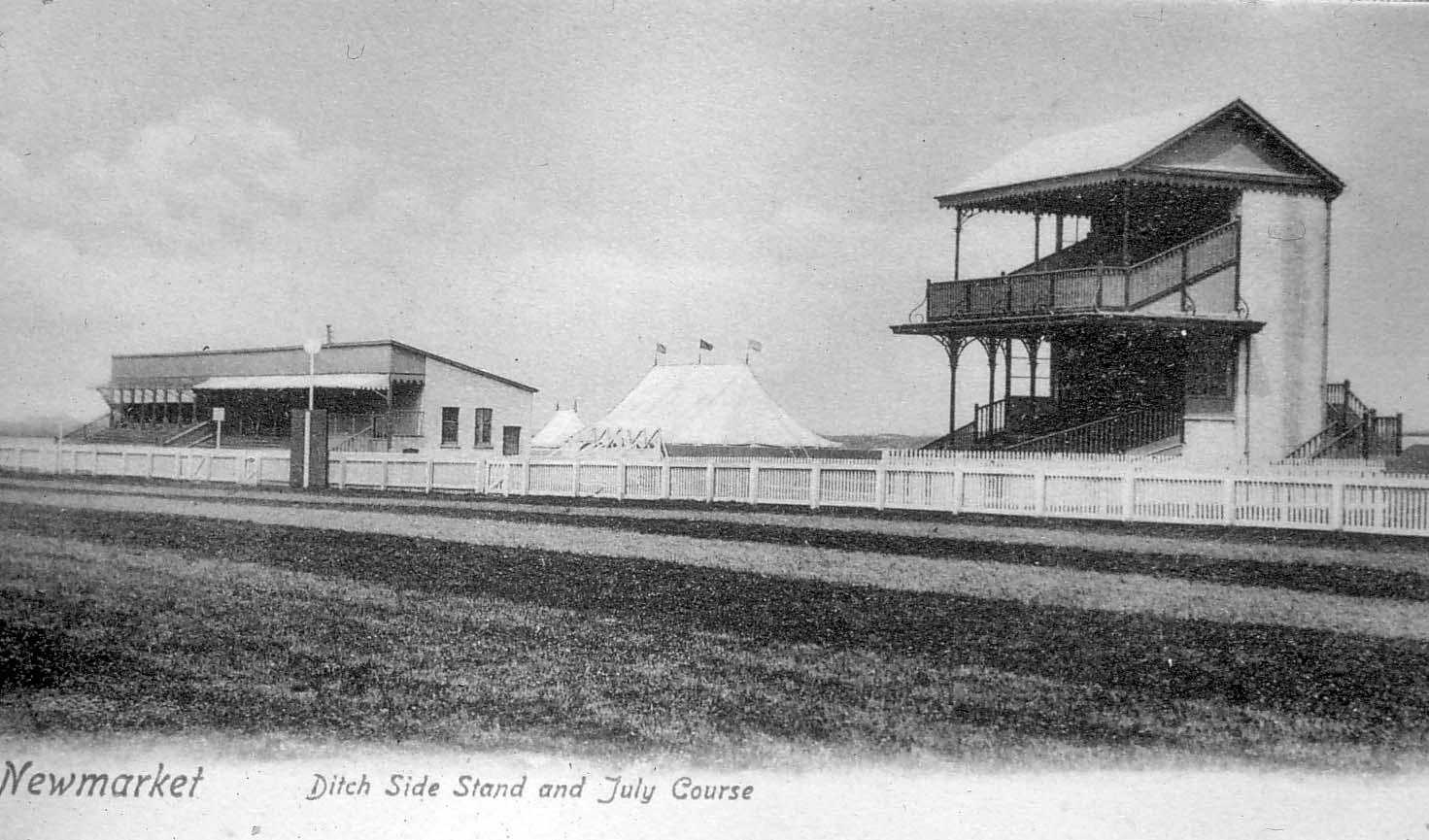
Ditch Side July Stands
Newmarket's Racecourses - Rowley Mile Stand and Cambridgeshire starting post - 1890
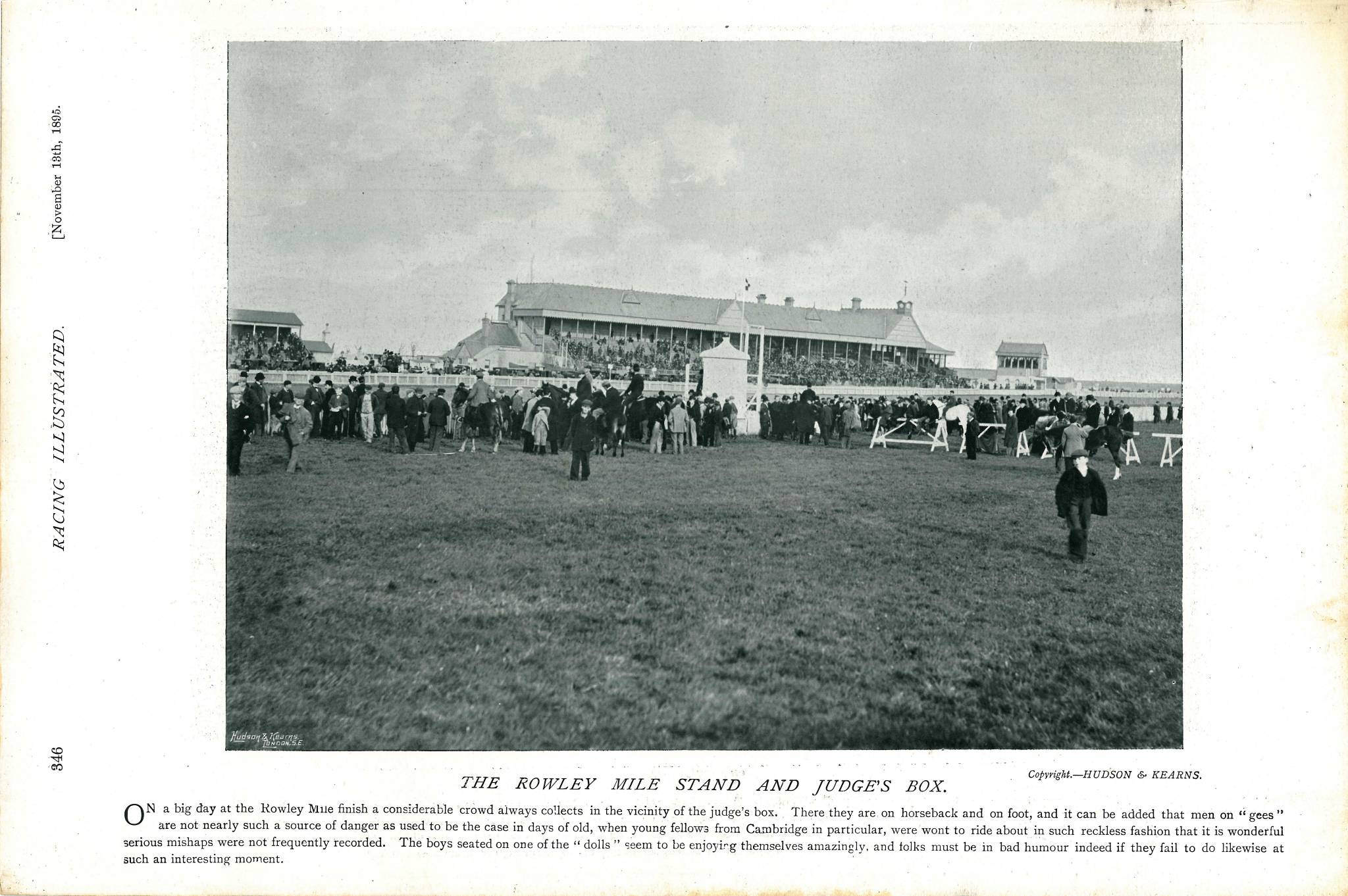
The Rowley Mile Stand and Judges Box 1895
-

Reproduced courtesy of Francis Frith.
Photo of the Rowley Mile Grandstand, 1922
-

Reproduced courtesy of Francis Frith.
Photo of the Rowley Mile Grandstand, c. 1960
-
The road shown in the top right-hand corner of this last map is now Hamilton Road,
note that the present-day short link onto the Cambridge Road was not there at this time.
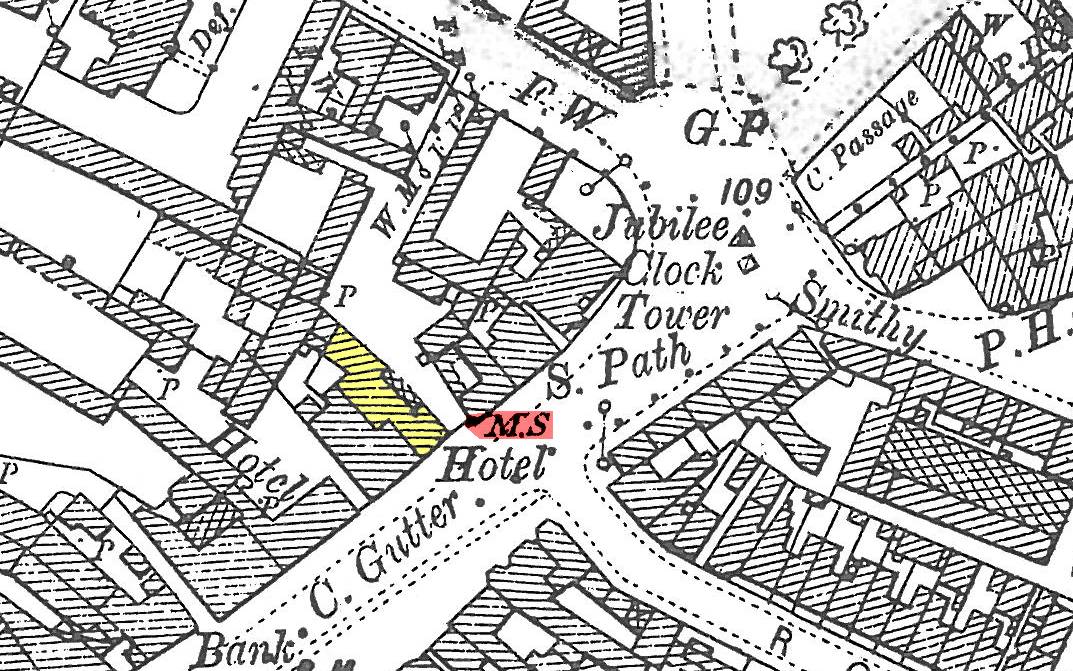
The first milestone from the Crown as previously mentioned can be seen identified as M.S. in the lower centre of the map - also showing that it is 58 miles from here to
London.
-
Newmarket's Racecourses in 1840
-
50 years back before these maps there were the older racecourses
as listed below:-
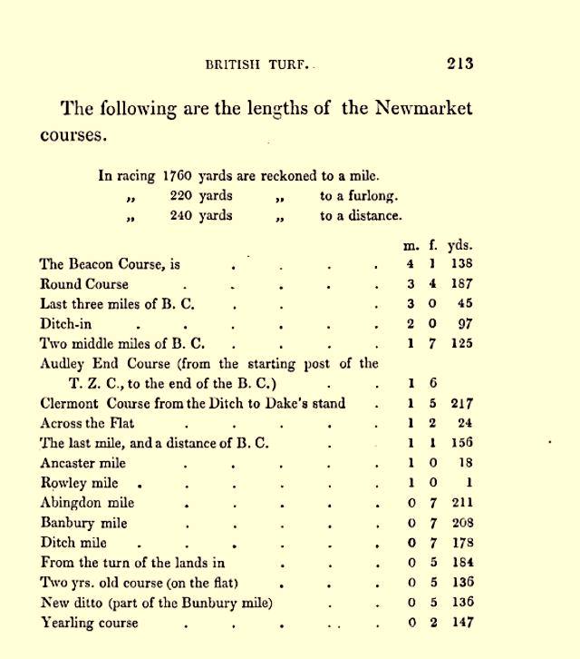
- Note that in the above list that the full length of the Beacon Course is
4 miles 1 furlong 138 yards. - this brings us back to the Four Mile Stable Farm,
as like Six Mile Bottom this also has a dual naming origin - it was originally the
saddling stable for the start of the Beacon Course and hence was (approximately)
four miles from the finishing post, which at this time was in front of the Cambridgeshire
Stand, more correctly known as the Portland Stand (as clearly shown
on the 1787 and 1902 maps further down this page).
-
Newmarket's Racecourses in 1787
-
Going back even further by another 53 years, shown below is what the end of the
Beacon and Cambridgeshire Courses looked like on Chapman's 1787 map of Newmarket:-
A lot of today's Newmarket wasn't there then, but a few landmarks do help in orientating the plan - the High Street and London / Cambridge Road runs across the centre of the map at an angle, stating '60miles from London' on it's left.
The White Lion pub was there then, showing that it's one of the more endearing establishments in the town and you can see the Dullingham Road entering at the bottom of the map onto the High Street as it does now .... though the windmill shown near there is now long gone. Also the cemetery wasn't there then, in its place was a short road cutting across the corner from the bend in the Dullingham Road.
Birdcage Walk and Hamilton Road also weren't there then, though the line of the enclosure hedging marks their later route.
The King's Stand is in the location of the Trainer's Stand on the 1890 map above and along with the nearby King's Stable that would have stood where Hamilton Road is today, they've both now disappeared.
The Portland Stand is the original name of the Cambridgeshire Stand, though it's a bit further over on the heath on this early map. The 1902 map below more clearly shows its later location.
The multiple tracks and cartways you can see wending their way from Reach over the heath were removed in the 1820s by the 4th Duke of Portland
- he had the end of the course re-turfed and levelled to remove these once dangerous ruts (see below for more details about the Duke of Portland's involvement in Newmarket's racecourses).
- So these are the
various stands that existed at this time at this end of the Beacon Course:-
- The King's Stable, also called the Rubbing-down House
- The Portland Stand
- The King's Stand
- ... and just to the west of the King's Stand (not shown on
this map) was the Duke's Stand
- The King's Stable, also called the Rubbing-down House
- Prince William Augustus (1721-1765), the Duke of Cumberland, was the third and youngest son of King George II.
He attended the races at Newmarket almost every year from 1753
until his death.
The Duke's Stand was named after him and had been erected near the end of the Beacon Course by the
early 1760s. Further details about him can be found on the page
for Charles
II's Palace.
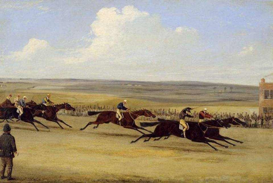
- George Stubbs' first
painting below shows three of these stands - to the left we have the
Rubbing-down House - in the mid distance is the King's Stand and
in the far distance is the white painted Duke's Stand. As detailed
below the Portland Stand hadn't been built at the time of
this painting, in 1765. The ditch in the foreground is the line of the
present-day Hamilton Road, where it joins the Cambridge Road. The Beacon Course
itself disappears off in the distance to the right of the painting
and the white post in-between the King's and Duke's Stands is the
finishing post, which was able to be moved to suit the particular race
that it was being used for.
Stubs' second painting below shows the grey stallion Gimcrack in front of the same Rubbing-down House. The King's Stand is still very obvious, but the Duke's Stand is not shown, although it's location would be somewhere behind where the horses are in the distance. The direction of both these views is looking south-west, and the line of the Cambridge Road is on the other side of the white railings behind the stands.
A point to note here is that all three of these buildings have hipped roofs; this is important in recognising them in any paintings in which they appear.
 Crown Mile Post 1901 |
|
|
 |
|
 The Round Course at Newmarket c.1725 |
||
A race on the Round Course at Newmarket - John Wootton [original at the The Fitzwilliam Museum, Cambridge] |
||
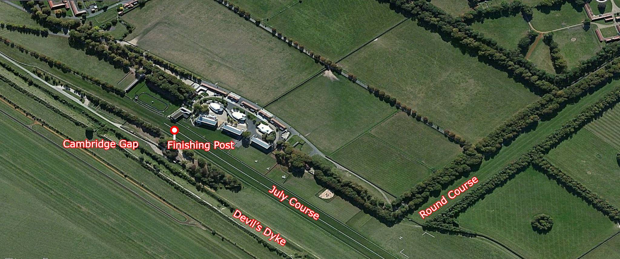 July and Round Course - aerial view 2013 |
||
 Newmarket's Racecourses - Cambridgeshire Stand - 1890 |
 Newmarket's Racecourses - History of the British Turf - by James Christie Whyte - 1840 |
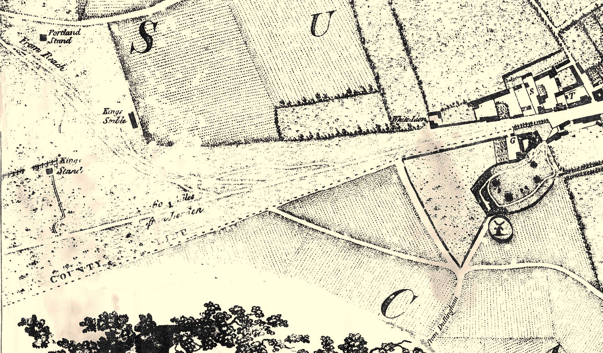 Chapman's Map of Newmarket 1787 |
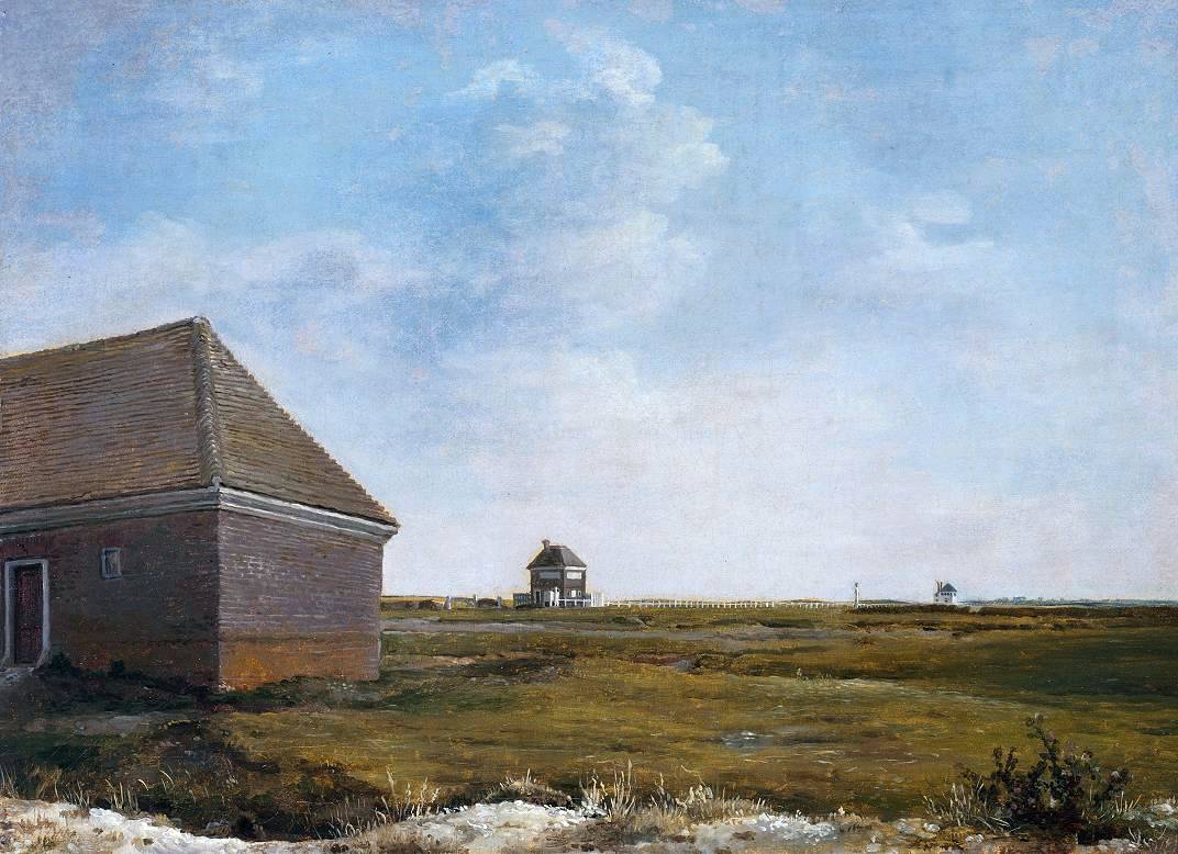 Newmarket Heath with a Rubbing-down House - painted by George Stubbs c.1765 |
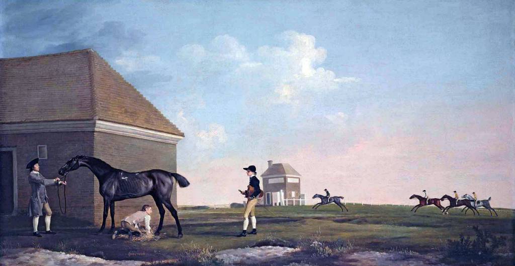 Gimcrack on Newmarket Heath - painted by George Stubbs c.1765 |
- The two paintings below, by John Nost Sartorius (1759–1828)
are of later races at the turn of the 18th century, and by this time the Portland
Stand had been
built and is clearly visible in the background just before the
winning post. These views are facing north-west and in the far
distance of the right-hand painting you can see two post mills and a
church on the brow of the hill - it's not entirely clear where this is, but scouring the
landscape on Google Earth seems to indicate that this could
possibly be
Burwell. At one time Burwell had up to four windmills, so this does seem
to be a highly likely location. Further on in the distance is a
much larger church - online this is attributed to being Ely
Cathedral ... in reality though this would unlikely to be visible
from this location and if it were it would appear much smaller ..
but then, this is just a painting!
Note that the Portland Stand has a flat roof - quite different in style to any of the older stands detailed above. You can see that the same building was still present in the 1850 painting above showing the finish of the Cambridgeshire Stakes, although by that time the roof-top viewing area had been removed.
All of these stands were eventually replaced by later incarnations and the 1902 map below shows the much larger later version of the Portland Stand. Also by that time all the other old stands had gone, to be replaced by the Trainer's Stand and Saddling Paddock.
-
Clearly shown on this 1902 map the days of the Portland Stand were numbered
at this time - it's still there on a later map for 1903, but as detailed in the
1914 newspaper article shown below it had been pulled down by then.
-
Although attributed in many scholarly articles to being built by William Henry Cavendish-Scott-Bentinck, the 4th Duke of Portland (1768-1854), it's
not as simple as that - as there's clearly a Portland Stand showing on Chapman's 1787 map, when he was only 18.
The stand isn't shown on the earlier of Chapman's maps in 1768; so
it must have been built sometime between 1768 and 1787.
Both he and his son Lord George Frederic Cavendish-Scott-Bentinck (1802-1848), did treasure the stand, move and extend it, and make copious use of it in the subsequent years, but it was actually the Grandfather - the 3rd Duke of Portland, William Henry Cavendish Cavendish-Bentinck (1738-1809), who commissioned and paid for construction of the original stand in 1774 - the following archived document clearly stating detailed financial transactions that were made at this time.
-
Manuscripts and Special Collections
The University of Nottingham
DocumentRef: Pw F 5880
Title: Letter from John Johnson, Berners Street [London], to [W.H.C. Cavendish-Bentinck], 3rd Duke of Portland, Burlington House [London]; 16 Apr. 1774
Requests payment of the balance due for the building of the Portland Stand at Newmarket race ground; states that he has a considerable payment to make in the middle of next week; includes details of the bill due from the duke and Lord Craven; the outstanding sum amounts to £126.5.3.
-
The youngster of these three Duke of Portlands, Lord George Bentinck, earned the unofficial title of
'Lord Paramount of the Turf' at Newmarket, and started many reforms including the use of a starting flag.
He also worked to eliminate fraud that was so prevalent in early
racing following the 'Dirty Derby' of 1844 (for further details of
this see the page for the
Golden Lion - No.44 High Street), and
he invented the horse box to move his horses to the races, without tiring them with a long ride to the venue.
-
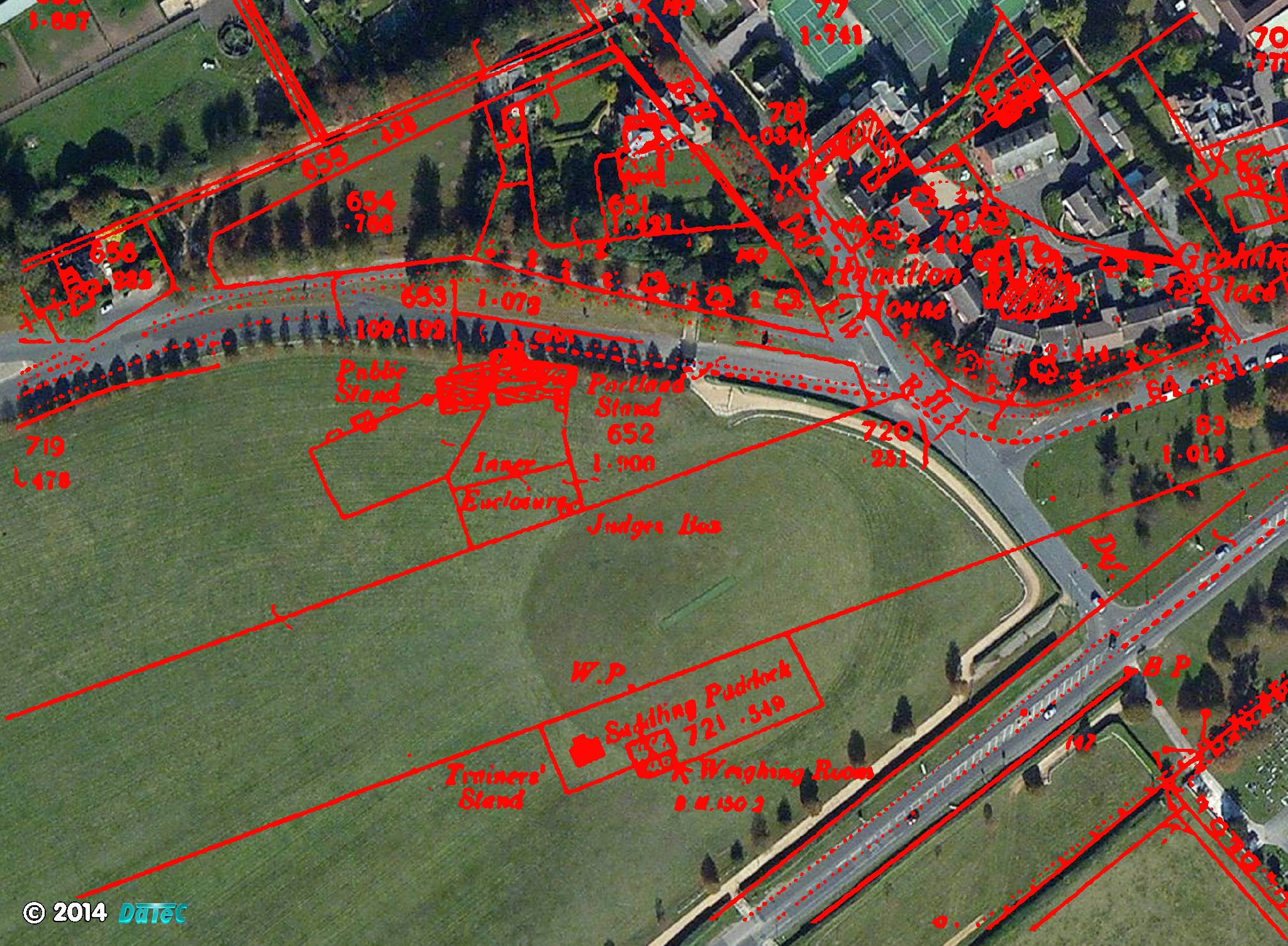
One other interesting anecdote from this 1902 map, and detailed in
the newspaper article below, the Saddling Paddock shown in the
bottom centre used to be popularly know as 'The Birdcage' -
presumably because all the horses and jockeys were in full public
view from the Portland Stand looking like they were in a birdcage.
Even though it's now gone the name lives on in the road that leads
up to here - Birdcage Walk.
-
The above picture shows the 1902 map of the Cambridgeshire (Portland) Stand
overlaid onto an aerial photo of the same area today.
Within the limits of mapping standards of the day the match between
them is actually quite good.
There's a building in the top left corner of the map and the red image of this is sitting pretty much on top of the house in the photo, the Cambridge Road lines up well along the bottom of the photo and the curve of what is now Birdcage Walk is also a good match, as is the private road down to the Rowley Mile course.
The present-day direct link between Hamilton Road and the Cambridge Road wasn't there in 1902.
This then shows quite clearly the position of the Portland and Public stands located against the side of the Rowley Mile private road.
The 'Birdcage' with its Trainer's Stand and Weighing Room was located on the southern part of the present-day practise cricket pitch, with the famous winning post (W.P.) for the Beacon & Cambridgeshire courses sitting quite close to the western end wicket position.
All this comparative positioning is of course within a few meters accuracy, but it does show pretty closely where these iconic buildings were situated on this end of the Cambridge Road heath.
-
Looking up the Cambridgeshire Course - where the Portland Stand once stood

New Zealand Herald, 3rd January 1914
- Written just before the start of WWI in 1914 the above newspaper
article describes how Newmarket's racecourses were changing rapidly
even then, from their earlier excruciatingly long distances to the more punter
satisfying and visible starting posts of the Rowley and Bunbury
(July) Miles.
-
Newmarket's first racecourse - 2, 4, 6, 8
- The earliest known racecourse at Newmarket was the Long Course and
this was longer again at eight miles distance, it started even
further away from Newmarket near Fleam Dyke along the London Road
(there's a 'burger & hotdog' stand that sits on the side of the
road at this location now) - hence it would seem that the course of
the present-day A11 dual carriageway follows even more of this
original racecourse.
One of the first records of a horse-race here was in 1613, when it was reported that 'the scarcity of lodgings in the town compelled many courtiers to stay at Linton near the other end of the course'. This very long distance course was primarily used for races between two horses, known as Matches.
Apparently the Long Course had its own mileposts along its length, which marked the starts for the shorter races, and there were stables at six, five and four miles (Four Mile Stable Farm), used for preparing the horses before a race.
With this in mind it makes more sense that Six Mile Bottom was named after the milepost and stables of the Long Course at this location - it is midway between Four Mile Stable Farm and the eight mile start at Fleam Dyke. Therefore in conclusion it would seem that the distance in its name most likely originated as the distance from the finishing post and not any of the starting posts as has been proposed elsewhere. The other part of its name is much easier to explain - the village sits in a slight dip in the land - a valley bottom.
This six mile distance was of course following the deviated route of the Long Course to the finishing post and not the direct path along the main road to Newmarket .... although it must not be forgotten - as previously stated it is indeed also six miles from here to the milestone (post) at the Crown Hotel - the 'Centre of Newmarket'
.... so what should be considered as most important to the history Newmarket - the racecourse or a pub? .... it's probably an even bet!
-
Further details of the various racecourses at Newmarket can be found on the National Horse Racing Museum website:-
http://blog.nhrm.co.uk/index.php/it-started-here-the-beacon-course-that-is/
-
Over the sticks at Newmarket!
- Newmarket is so well known for flat racing that it's easy to
forget that at one time in addition to the multitude of flat racing
courses detailed above it was also host to a steeplechase course.
The swathe of land on the other side of the London / Cambridge Road that is now the Newmarket Links Golf Club was at one time the Jockey Club owned Links Farm, steeplechase and polo ground.
The first recorded steeplechase over a prepared track with fences was run at Bedford in 1810, although a race had been run at Newmarket in 1794 over a mile with five-foot bars every quarter mile. In an early 1900s article about steeplechasing Newmarket's course was described as 'a model of a galloping course, with fair fences of good size'.
The success of the flat courses at Newmarket though overshadowed the steeplechase and with so many other successful venues for the sport elsewhere it slowly disappeared from the fixture list. The original 18 holes of the Links Golf Club were set out in 1903.
Even today though there are still facilities for the training of steeplechasers and hurdlers at Newmarket, many trainers hold dual purpose licences and the national hunt training facilities are still based at the Links between the golf course and railway line.
-
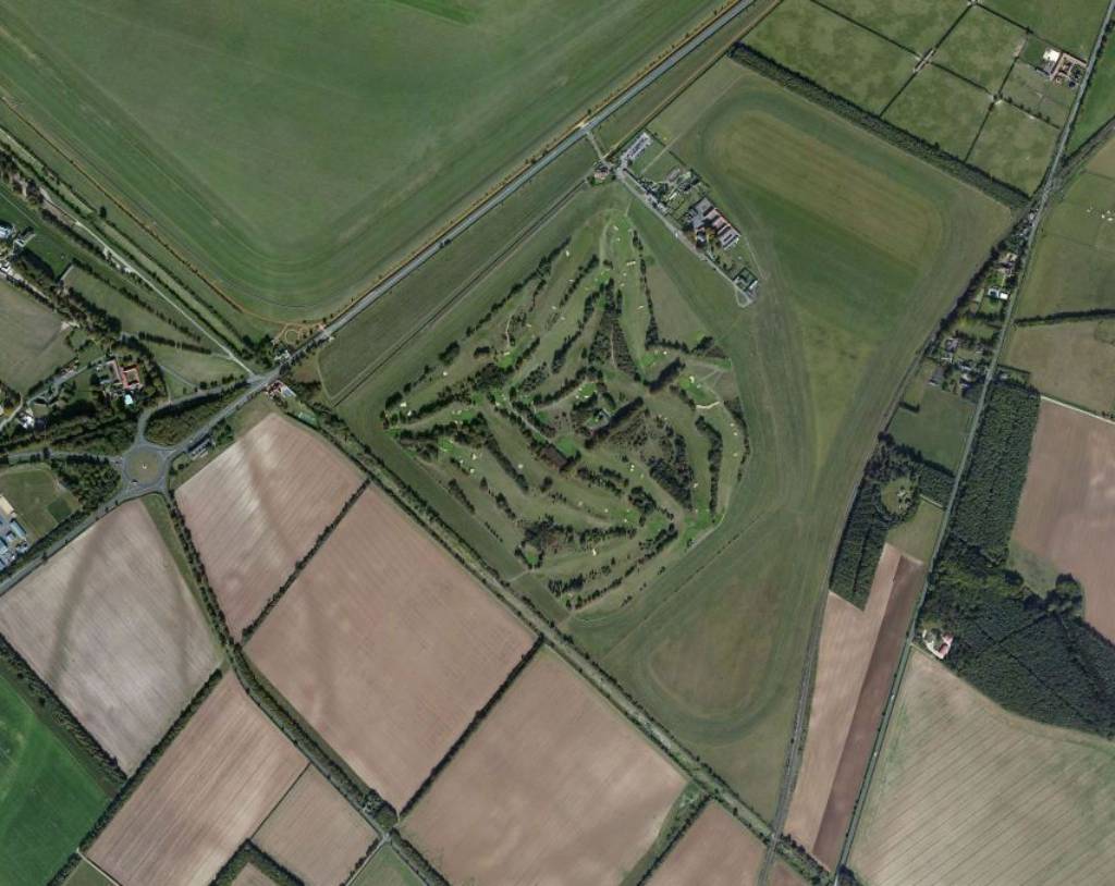
Newmarket Links & National Hunt Training Course - aerial view 2013
Old Grandstand Links Steeplechase Course c. 1890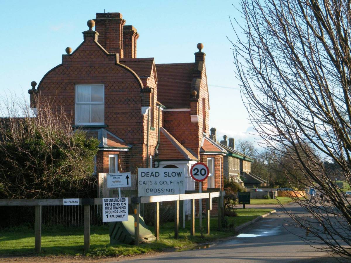
The Links Golf Course 2013
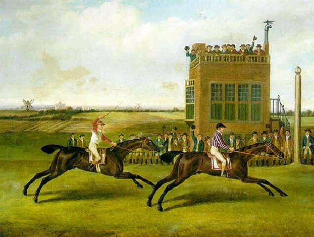
The Duke of Bedford's Grey Diomed beating H.R.H. The Prince of Wales' Traveller over the Beacon Course at Newmarket for 500gns - painting by John Nost Sartorius - 8th May 1790 |
 The winning post at Newmarket with Pavilion beating Sancho - the Duke of Portland's stand shown beyond - painting by John Nost Sartorius - the New Claret Stakes at the Newmarket First Spring Meeting, 29th April 1805 |
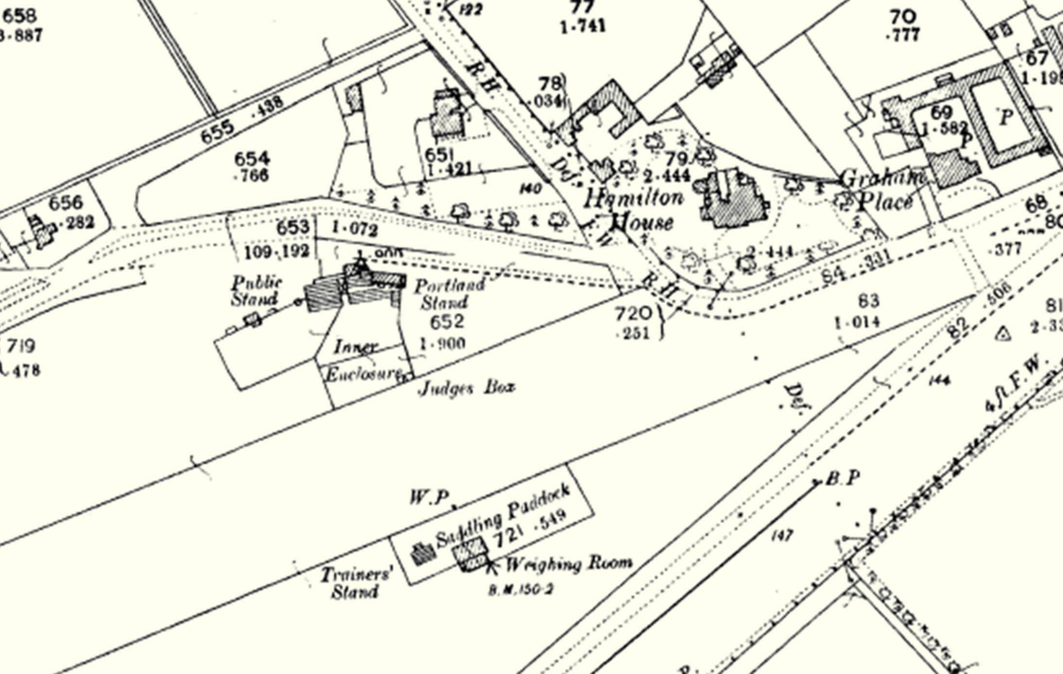 Map of the Portland Stand 1902 |
|
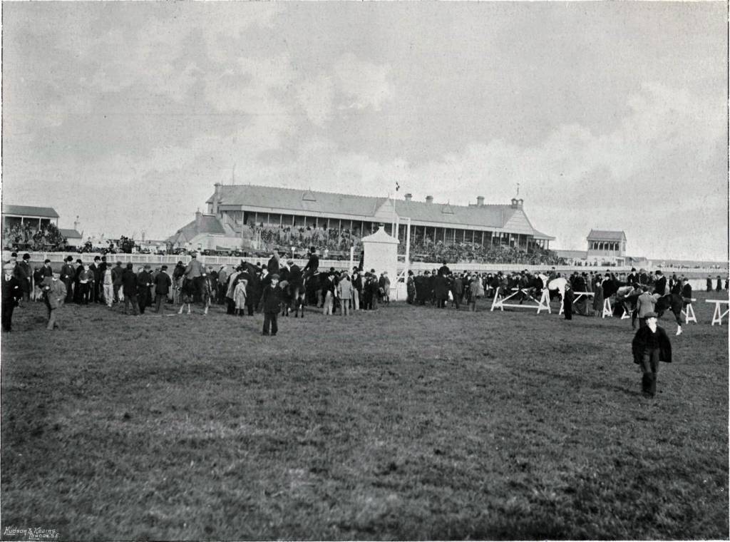
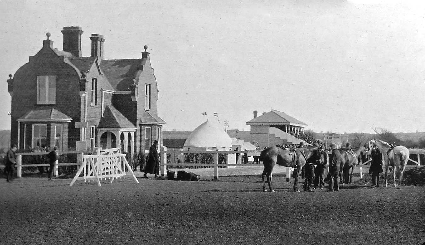
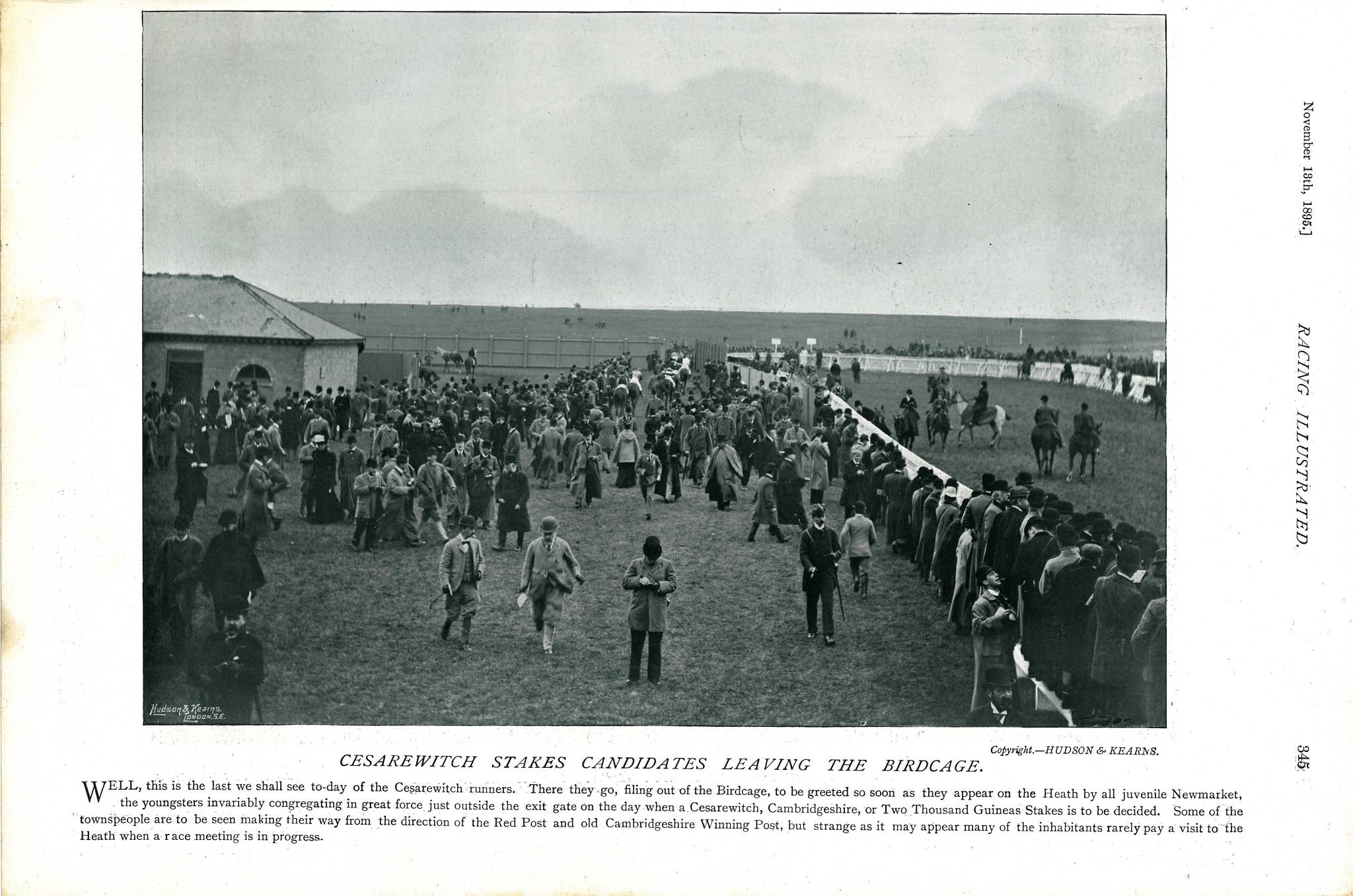 Cesarewitch Stakes Candidates Leaving 'The Birdcage' 1895 |
 |
-
In the old photo on the left above you can see the public entrance
onto the Steeplechase Course and the main grandstand at the
finishing post in the background.
Later photos show two identical grandstands next door to each other. Note that these grandstands were not demolished - the seating steps at the front of them were knocked off and the buildings behind were converted into houses.
Both these houses can still be seen in the background in the 2013 photo on the right, taken at the entrance of the Links Golf Course.
The red-bricked building in the foreground looks almost unchanged - quite a feat, considering that over 120 years have passed between these two photos.
Many thanks to Peter Norman for the c. 1890 photo.
-
Return to top of page